Digital twins for architects & construction teams

Capture the site once. Keep the context.

Record a building or work area with an ordinary smartphone. Review it remotely, attach issues and instructions, then help the next person find the exact physical location on site.

Available in early 2027. Register for updates or send us a question.

See where it fits
  • Phone-first capture
  • On-site AR guidance
  • Persistent building memory
Where exactly is the problem?
What does this area look like today?
What is hidden behind this surface?
What should happen here next?

A practical kind of digital twin

Not every building needs to become a smart city.

Large infrastructure twins connect BIM, IoT sensors and facility-management systems across airports, plants and cities. That is one valuable use of the technology—but it is not the only one.

Houses, offices, apartment buildings, retail spaces and smaller commercial properties need a faster answer: capture what is actually on site, preserve the important details and show the next person exactly where work needs to happen.

The old record

Photos, plans, measurements, notes—and memory.

A photograph can show a defect without showing where it was taken. A note can name a room without identifying the correct pipe, valve or fitting.

“Pipe leaking above suspended ceiling near office 204.”

Where GuideMeAR fits

Spatial context quick enough for everyday work.

GuideMeAR does not replace professional land surveying, registered point clouds, laser scanning or high-accuracy Scan-to-BIM workflows.

When millimeter-level measurements or certified surveying data are required, dedicated systems remain the right tool. GuideMeAR serves the operational space between a drawing and the physical place where the work happens.

01 · Existing conditions

Capture the building before design work begins.

Replace a disconnected camera roll with a navigable spatial reference the whole project team can revisit remotely.

Architects often leave a renovation survey with hundreds of photographs, measurements and sketches. Days later, simple questions become hard to answer.

“Which wall was this?”
“Was this pipe in the bathroom or the utility room?”

A smartphone recording creates a navigable 3D representation that keeps each detail connected to its location.

01 Structural concerns
02 Existing utilities
03 Windows and doors
04 Areas needing measurement
05 Damaged surfaces
06 HVAC equipment
07 Plumbing access
08 Electrical panels
09 Unusual construction details
02

Reduce unnecessary return visits

Stop asking, “Did anyone photograph that?”

A designer can inspect the space behind a staircase, a contractor can review pipes in a utility room and an engineer can revisit an existing connection without automatically sending someone back to the property.

From issue to action

Make the location part of the task itself.

Photographs and descriptions explain what is wrong. A spatial annotation also shows precisely where it is wrong.

03

Create a spatial punch list

Attach the issue to the affected location, so room numbers and photographs no longer have to carry all of the context.

  1. 1Find the task
  2. 2Navigate to the area
  3. 3Identify the exact location
  4. 4Perform the repair
  5. 5Update the status
04

Show contractors what needs repair

Turn a defect into a persistent spatial annotation with the exact instruction, responsible party and completion evidence attached.

Window 08

Water penetration below frame
  • Inspect exterior flashing
  • Reseal lower-right connection
  • Upload completion photograph

This is not primarily a 3D-modeling problem. It is a communication and localization problem.

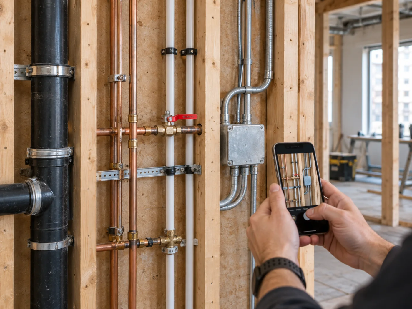
A technician documenting pipes, conduits and a junction box before a wall is closed
Recorded before closing

05 · Before it disappears

Preserve information before walls and ceilings are closed.

Some of the most valuable construction information vanishes behind drywall and suspended ceilings. Record it while pipes, cables, valves, junctions and reinforcements are still visible.

Electrical cable routesWater pipes and heating linesShut-off valvesDrainage connectionsJunction boxesInspection openingsStructural reinforcementsUnusual construction details

06 · A better handover

Let the building become its own maintenance manual.

Connect manuals, dates, contacts and procedures to the physical asset instead of leaving the owner with another folder to search two years later.

Heat pump

Model, installation date, filter procedure, service contact and manual.

Attached to this place

Main water shut-off

Precise location, closing direction and emergency instructions.

Attached to this place

Electrical panel

Circuit information, inspection date and contractor details.

Attached to this place

07 · Find unfamiliar assets

Give technicians the last few meters of context.

A floor plan can say “AHU-03, second floor.” GuideMeAR can preserve the visual and spatial context recorded by someone who already knows the building.

Isolation valveElectrical cabinetCeiling access pointHVAC unitNetwork cabinetPump or sensorService hatch

08 · Spatial work instruction

Roof leak · north-west corner

On site
01
Locate

Inspect the flashing connection at this corner.

02
Open

Remove sealant along this 30 cm section.

03
Verify

Check the membrane beneath the flashing before resealing.
The result is closer to a spatial work instruction than a conventional site model.

The right tool at the right scale

GIS, BIM and GuideMeAR solve different problems.

A building may exist in GIS. Its design may exist in BIM. GuideMeAR carries the final practical context to the person standing in front of the work.

SystemTypical scalePrimary question
GISCity, campus, infrastructure networkWhere is the asset?
BIMBuilding and building systemsWhat is the asset and how is it designed?
GuideMeARRoom, component, defect or work areaWhat happened here and what should someone do here?

Capture only what matters

You do not need to digitize the entire site.

The goal is not a perfect copy of every square meter. Preserve the spatial information that would otherwise require another visit, explanation or search.

Residential renovation

  • Kitchen before demolition
  • Bathrooms
  • Electrical panel
  • Hidden services

Office renovation

  • Mechanical rooms
  • Ceiling infrastructure
  • Communications rooms
  • Unresolved defects

Apartment maintenance

  • Boiler room
  • Roof equipment
  • Utility risers
  • Electrical rooms

Defect management

  • Capture only rooms with outstanding issues
  • Return after repair
  • Preserve completion evidence

A phone-first approach

Right-sized for smaller projects.

Professional LiDAR, 360° capture and Scan-to-BIM workflows remain valuable when accuracy and comprehensive coverage are required. A small practice may simply need to walk the property with the phone already in a pocket and keep enough context to avoid another visit.

Without requiring

  • Specialist scanning contractor
  • Dedicated 360° camera
  • LiDAR scanning workflow
  • BIM coordination infrastructure
  • Enterprise implementation
  • IoT-connected building twin

Useful long after construction

A digital memory for smaller buildings.

Construction knowledge should not disappear at handover. Preserve the routes, products, shut-offs, previous issues, access steps, contractors and maintenance procedures that future teams will need.

01what is here
02what happened here
03what is hidden here
04what someone should do here next

GuideMeAR Digital Twin

Capture the site once. Keep the context for every future visit.

Document existing conditions, mark construction issues and give maintenance teams spatial guidance using only a smartphone.

Available in early 2027. Register for updates or use the form to send us a question.